Using dip-wells to measure water table depth (WTD) to determine hydrological condition of natural wetlands
Why measure water table depth?
Maintaining good condition for wetland ecosystems categorised as blanket bog, lowland raised bog, purple moor grass & rush pasture, lowland meadows and wet woodlands depends upon a naturally high water table. Drainage programmes, mostly government funded from the 1850s through to the 1980’s have been successful in achieving an increase in the water table depth and a corresponding improvement in agricultural production. However, this has come at a cost to wetland habitat condition and ecosystem services that wetlands provide. Whilst engineering processes to return the land to a high water table can be simple or complex and variable in their success, measuring the progress in hydrological terms can be straightforward and informs when further modification to land management is required. Measuring progress through vegetative analysis is over the longer term (5-10 years).
With 85% of Northern Irelands 242,000 hectares of peatland classified as modified (4) and therefore being in unfavourable habitat condition, posing a wildfire risk and net emitters of greenhouse gases, re-wetting is likely to be the main driver in the NI peatland strategy. (5)
Hydrology & Peatland Restoration
The first stage of peatland restoration is the creation of the correct hydrological conditions. The water table depth should ideally be within 10-15cms of the bog surface for 90% of the year. A collation of data across 16 UK and Irish peatland sites has estimated that for every 10cms of water table depth below 30cm there is an annual greenhouse gas emission of 3 t CO2 equivalent/ha(3). Whilst raising the water table above this height increases methane emissions, the further reduction in CO2 emissions, the longer term peat accumulation and the shorter term nature of methane in the atmosphere means that the linear beneficial relationship of a higher water table continues until 8cm from the surface.
How to monitor groundwater levels.
Routine or long term measurement of water table depth is carried out using monitoring holes installed with piezometers or dip-wells, with recordings taken by hand device or a submerged data logger. Dip-wells are slotted tubes installed to a depth greater than the lowest known/anticipated water table. The tubes are slotted/perforated to within 25cm of the soil surface and covered in a geotextile fabric to allow ingress of soil water, but not larger soil particles. Avoiding perforation to the soil surface eliminates the problem of overland flow affecting water table measurement. Water table varies with rainfall, evapotranspiration, and the artificial and natural drainage characteristics of the profile. Peizometers are tubes where the water ingress holes are only at the bottom and is used to record water pressure and therefore level in a specific layer such as where there is a perched water table and an impermeable layer above.
Monitoring Equipment
Dip-wells or piezometers are generally used in clusters of 3 up to 20m apart. This is due to the variability of peatland and the necessity to ensure that a representative measurement is being taken. Dip wells or piezometers are available to purchase commercially varying from £45 – 150 each. Simple and effective dip wells can be constructed from waste water pipe, geotextile fabric and duct tape costing £4 each. A measurement device, known locally as a “plopper” can be simply made from copper pipe and a measuring tape, with readings taken monthly or only occasionally as required in dry periods. For demonstration or research sites a data logger left suspended in the well can be used to take readings at 20 minute intervals with data downloaded once or twice per year.
Demonstration & Knowledge Transfer
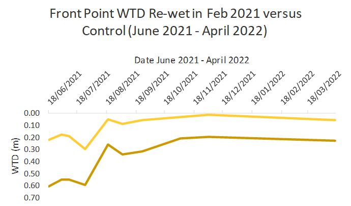
CAFRE Hill Farm has a range of piezometer and dip-well clusters across a range of open moorland, re-wet open moorland, forest to bog and semi natural grassland sites. These will be used to demonstrate the importance of hydrological conditions for wetland habitat, and how to monitor re-wetting programmes.
Water table depths on moorland, forest and grassland blanket bog sites across the hill farm centre, vary between 30– 60cm below the surface, in the early summer dry spell. Restoration and re-wetting programmes in 2020 and 2021 have successfully demonstrated a reduction in water table depth to 10-20cm.
This simple technology will be applicable to land managers across most peatlands in NI as policy moves gradually to a re-wetting strategy.
References
- Environment Agency. A Guide to Monitoring Water Levels and Flows at Wetland Sites. National Groundwater and Contaminated Land Centre.
- Hatano, R. 15TH INTERNATIONAL PEAT CONGRESS 2016. EMISSIONS OF METHANE AND NITROUS OXIDE FROM PEATLANDS, Research Faculty of Agriculture, Hokkaido University
- Evans, C.D et al. Nature volume 593, pages 548–552 21 April 2021 Overriding water table control on managed peatland greenhouse gas emissions
- Implementation of an Emissions Inventory for UK Peatlands (defra.gov.uk)
- NI Peatland Strategy Consultation